
This project is to plan, design and construct improvements along approximately nine (9) miles of Coyote Creek, between Montague Expressway and Tully Road, in San José. The primary objective is to provide protection from floods up to the level that occurred on February 21, 2017, equivalent to approximately a 5% flood (20-year event). In December 2019, the Valley Water Board of Directors voted to allocate local funding for construction of the preferred project; however, Valley Water is also exploring additional external funding sources and partnership opportunities.
Since 2017, Valley Water has implemented several short-term interim projects to help reduce the risk of flooding along Coyote Creek. These include the installation of an interim floodwall and embankment along the creek in the Rock Springs community. This structure protects the Rock Springs community from a flood event equivalent to the February 2017 flood. Other interim projects include repairing a 150-foot levee adjacent to the South Bay Mobile Home Park, installing flood gauges on bridges that provide real-time visual information on water levels and removing invasive vegetation from Valley Water and City property in parts of the creek that experienced the most flooding.


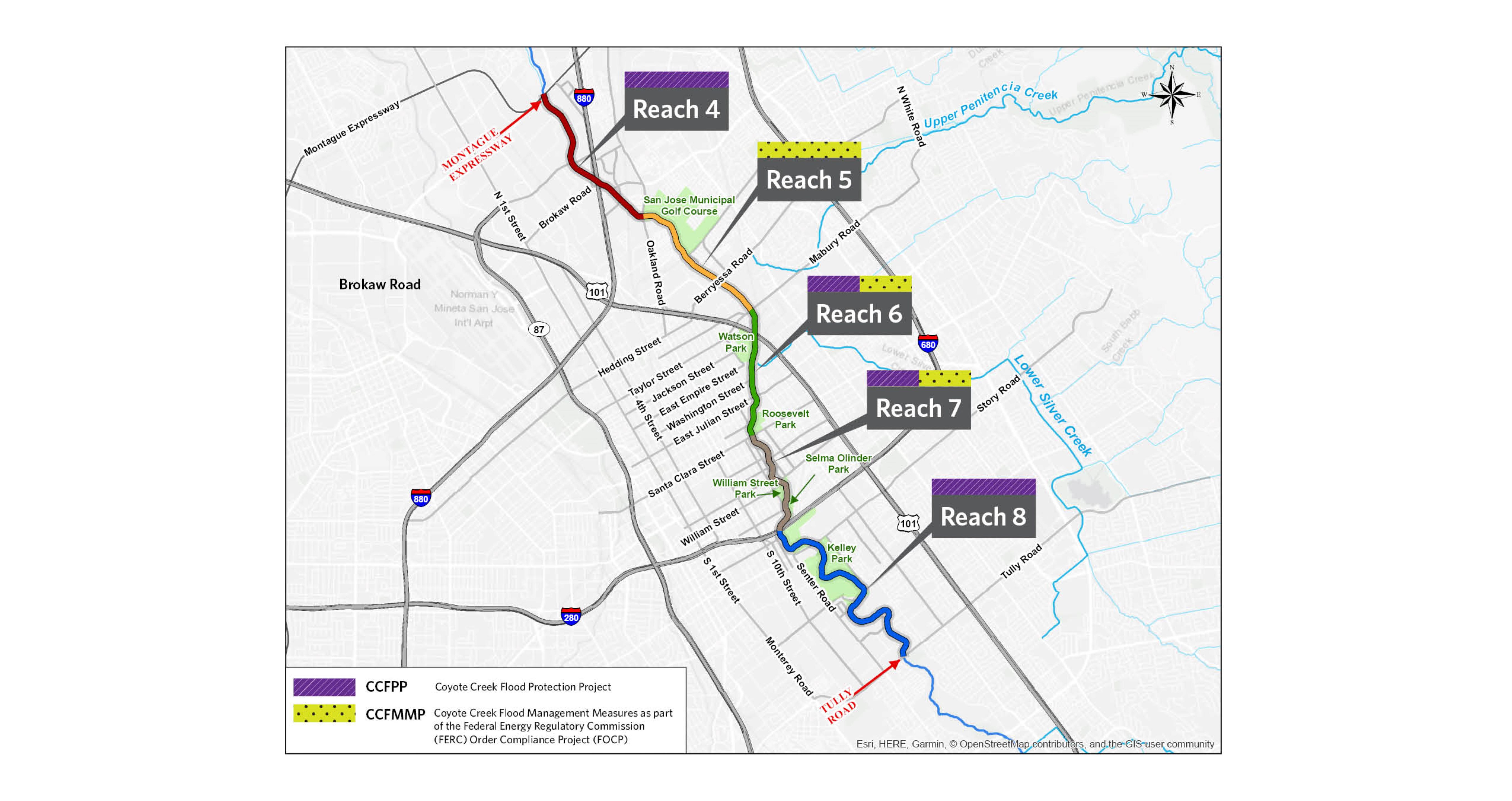
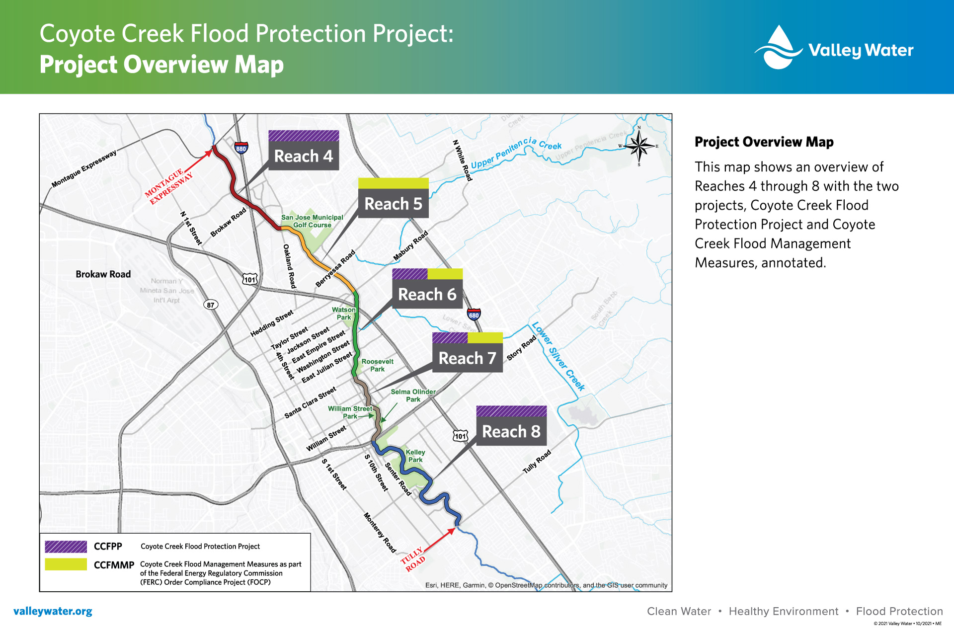
The Coyote Creek Flood Protection Project comprises two projects: the Coyote Creek Flood Management Measures for the FERC Order Compliance Project (CCFMMP or Phase 1) and the Coyote Creek Flood Protection Project (CCFPP or Phase 2). The CCFPP is in the design phase, with staff actively evaluating critical data from various sections along Coyote Creek. The map to the right shows reach 5 and sections of reaches 6 and 7, as part of the CCFMMP, which are in construction through the end of 2024. Reaches 4, 8, and parts of reaches 6 and 7 are part of the CCFPP, with construction anticipated to start in mid-2025 and be completed by the end of 2027. Reaches are sections where the work will take place along the creek.
Coyote Creek Flood Protection Project (CCFPP)
The CCFPP is currently in the design phase, with various flood reduction elements proposed at different locations along nine miles of Coyote Creek to provide flood protection to the 2017 level of flooding. Project information is available to download.
Coyote Creek Flood Protection Project Design Update and Draft Environmental Impact Report (EIR) meeting
Valley Water hosted two public meetings on the Coyote Creek Flood Protection Project. Staff will provide an update on the project’s flood protection measures designed to reduce the risk of flooding from an event equivalent to the February 2017 storm event.
The presented project information included details about the flood protection measures to be built along Coyote Creek and at Kelley, Rocksprings, Selma Olinder, Watson, and William Street Parks. Phase 2 of the Coyote Creek Flood Protection Project is currently in the design phase and construction is anticipated to start in the summer of 2025. The Draft Environmental Impact Report is projected to be available in June 2024 with a public meeting to follow.
| April 17, 2024 | April 18, 2024 |
|
Meeting recording |
Meeting Agenda |
Mid-2025 Construction site-maps
The Coyote Creek Flood Protection Project (CCFPP) is in the design phase. The following maps provide details of the locations and type of flood risk reduction measures.
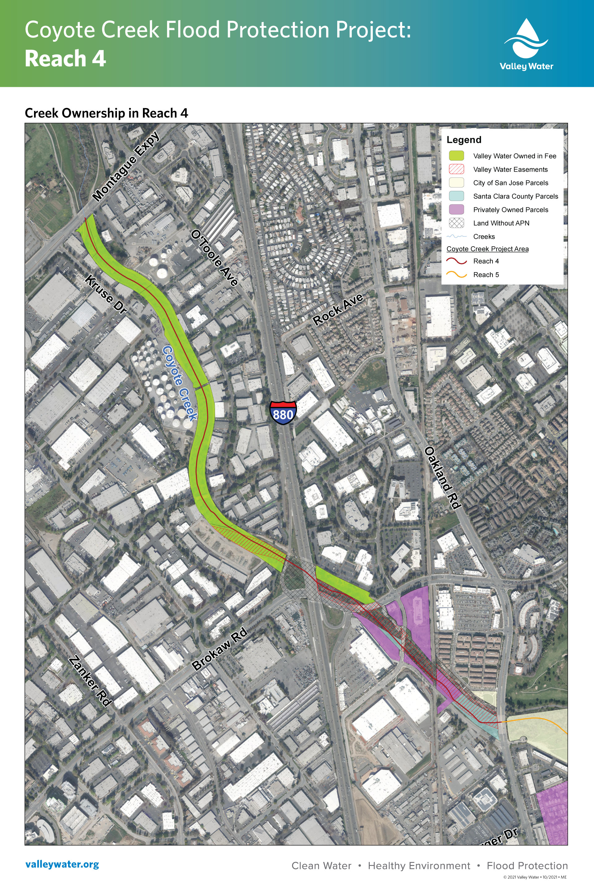
- Reach 4: Montague Expressway to E. Brokaw Rd.
- Reach 6: Mabury Rd to East bank of Coyote Creek behind Empire Gardens Elementary School
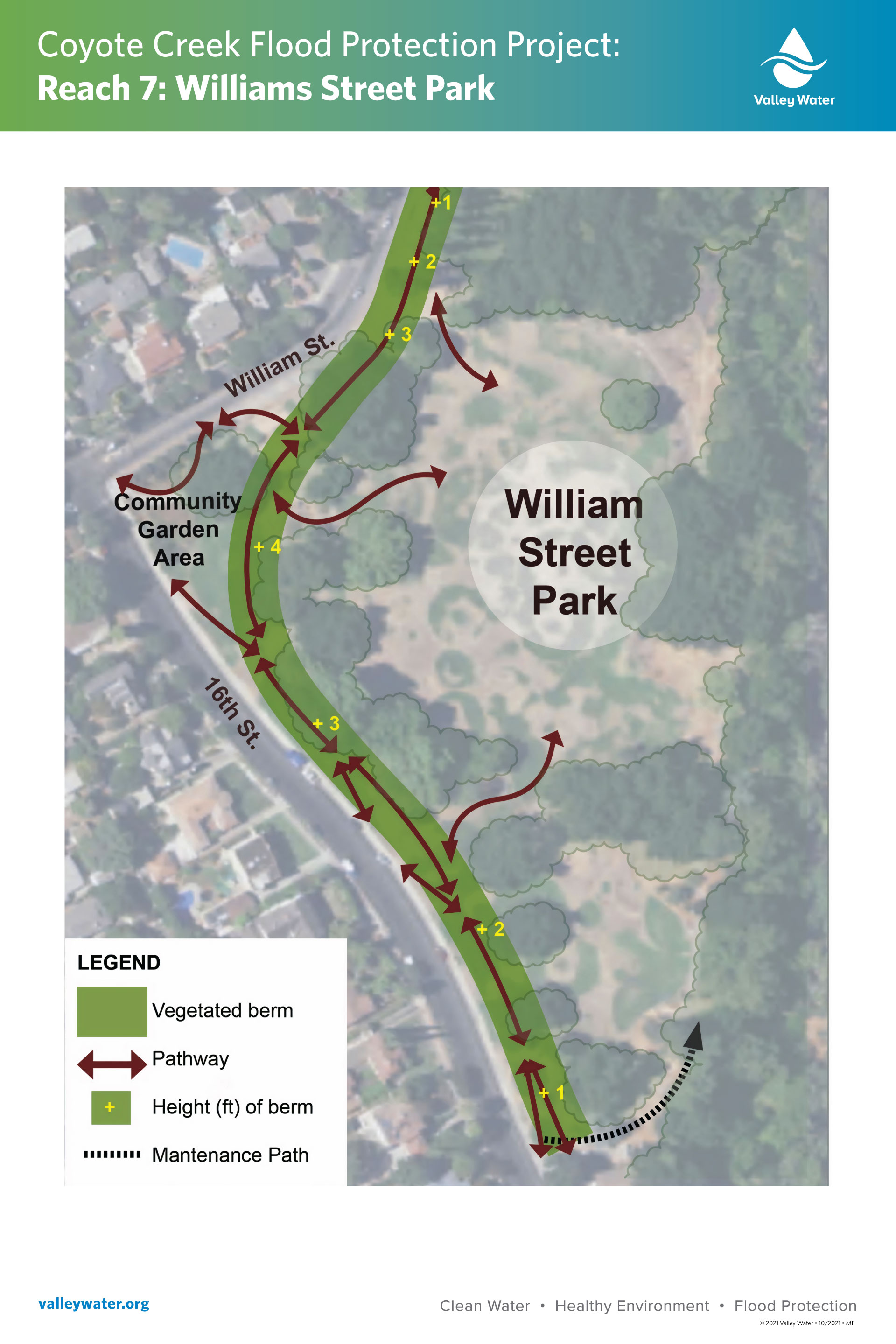
- Reach 7: Coyote Creek Classroom to Selma Olinder Park/Highway 280
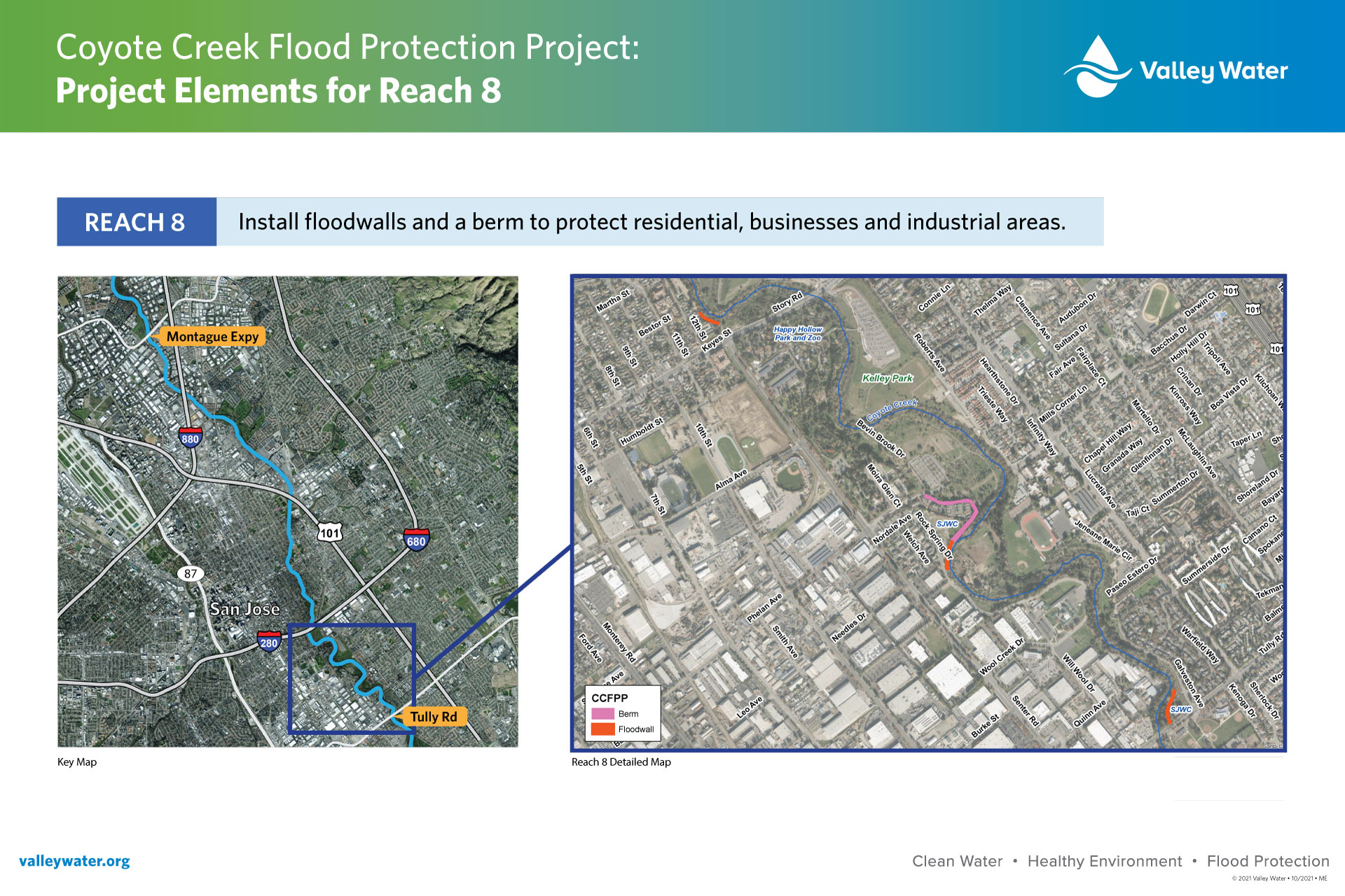
- Reach 8: Highway 280 to Tully Rd.
Coyote Creek Flood Management Measures Project (CCFMMP)
The construction of CCFMMP started in June 2023. Floodwalls are being installed along various sections of Coyote Creek between Old Oakland Road and Highway 280. Below are maps of the reaches where work is scheduled for the CCFMMP. Crews are working Monday through Friday, from 7 a.m. to 7 p.m., to install metal sheet piles along Coyote Creek, using a press-in method that produces low noise. Work may also occur on Saturdays to help advance project construction.
Valley Water’s project activities include the installation of floodwalls. Workers will install metal pieces called sheet piles along Coyote Creek, using a press-in method that produces less noise than typical construction techniques. During this effort, some neighboring properties may experience typical construction noise and minor vibrations. The work is scheduled for Monday through Friday, from 7 a.m. to 7 p.m.
Current construction work and site activities
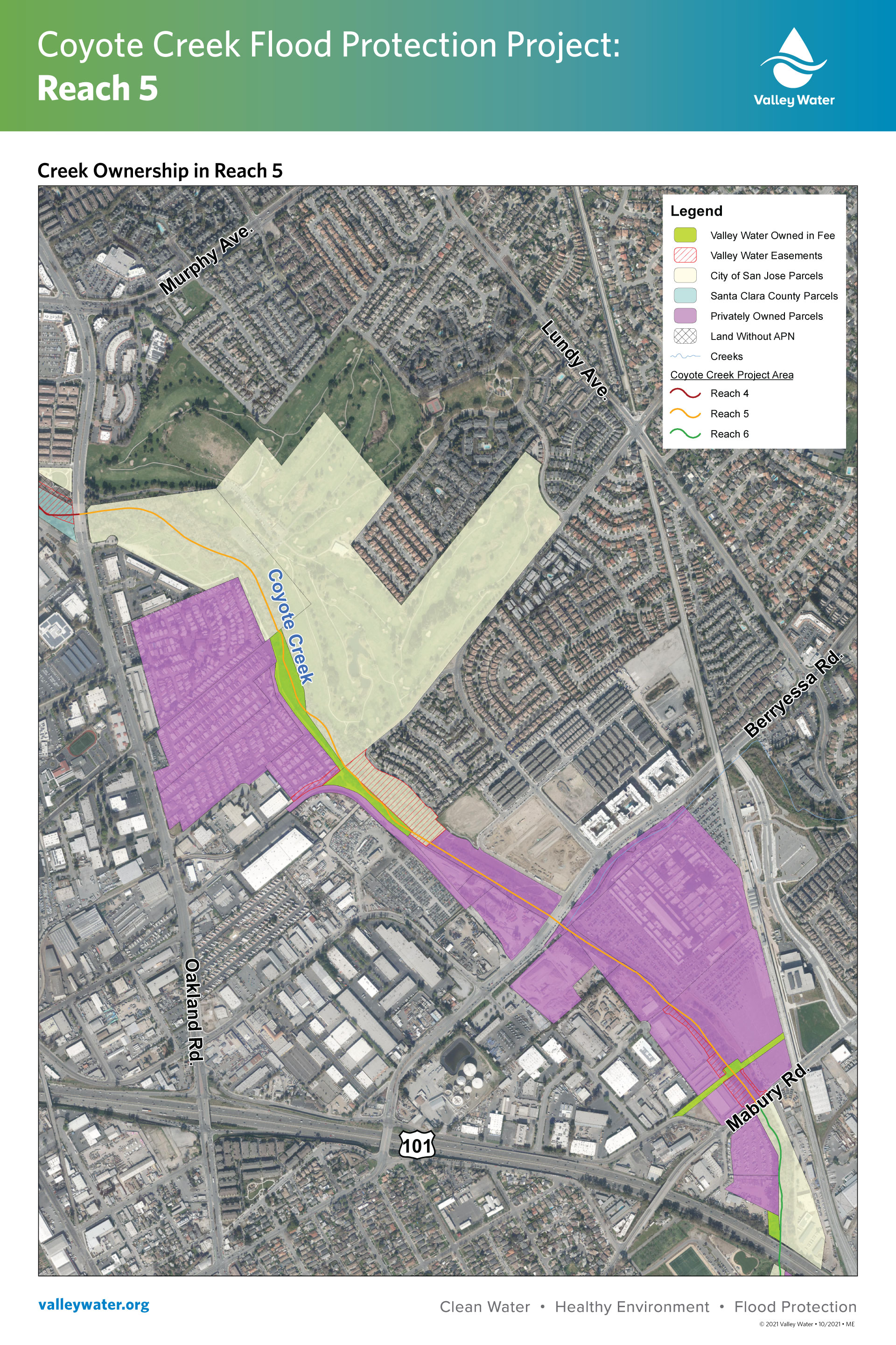
Reach 5: San Jose Municipal Golf Course to Mabury Rd and creek ownership map.
In fiscal year 2024, quarter 3, crews installed floodwalls along the west bank of Coyote Creek north and south of Berryessa Rd. and on a portion of Notting Hill Dr. Please use caution when driving near the project areas and follow all traffic control measures.
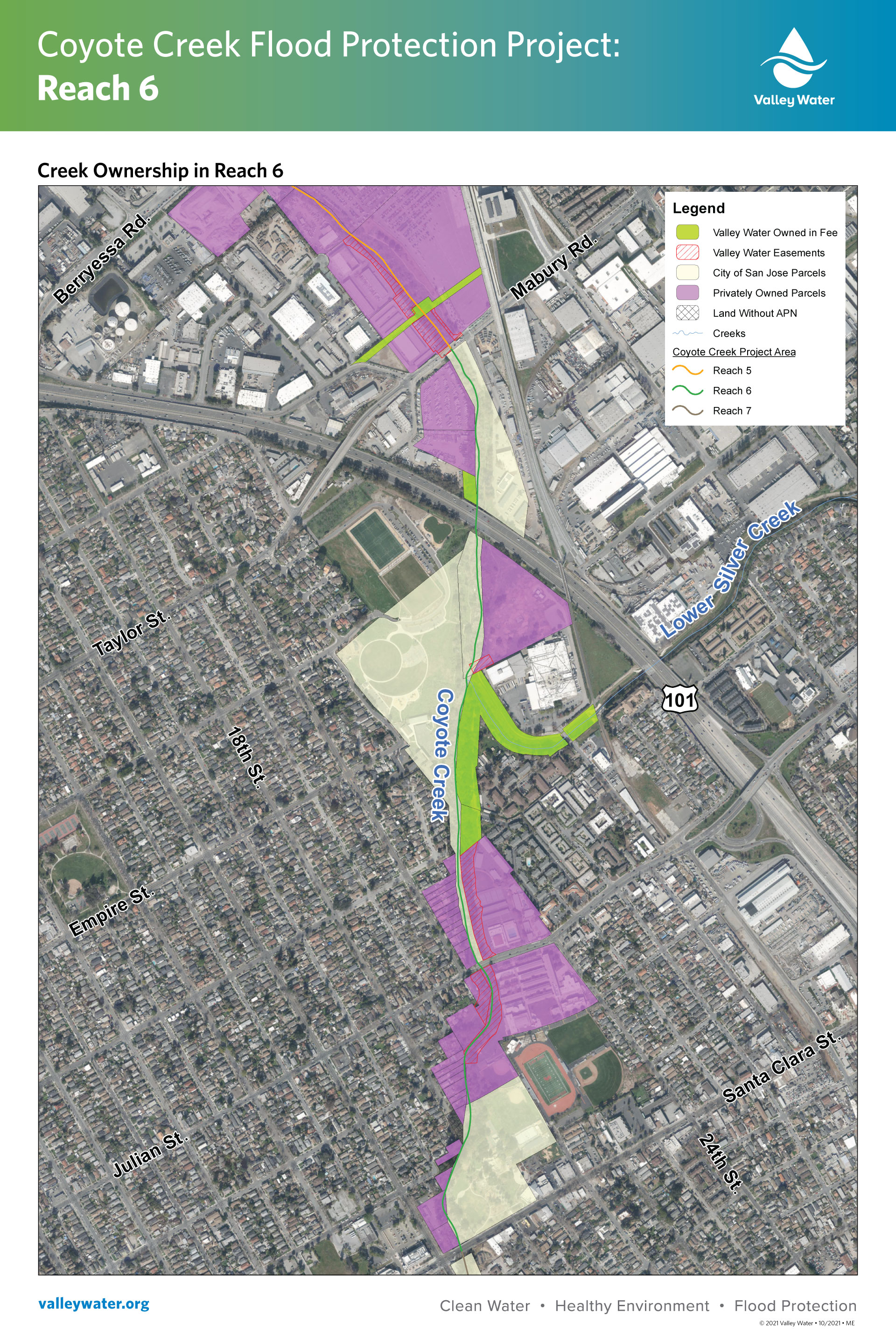
Reach 6: Mabury Rd. to U.S. Highway 101 and creek ownership map
In fiscal year 2024, quarter 3, crews installed floodwalls along the west bank of Coyote Creek north of Highway 101 and south of Mabury Road. The floodwall construction will continue into fiscal year 2024, quarter 4.
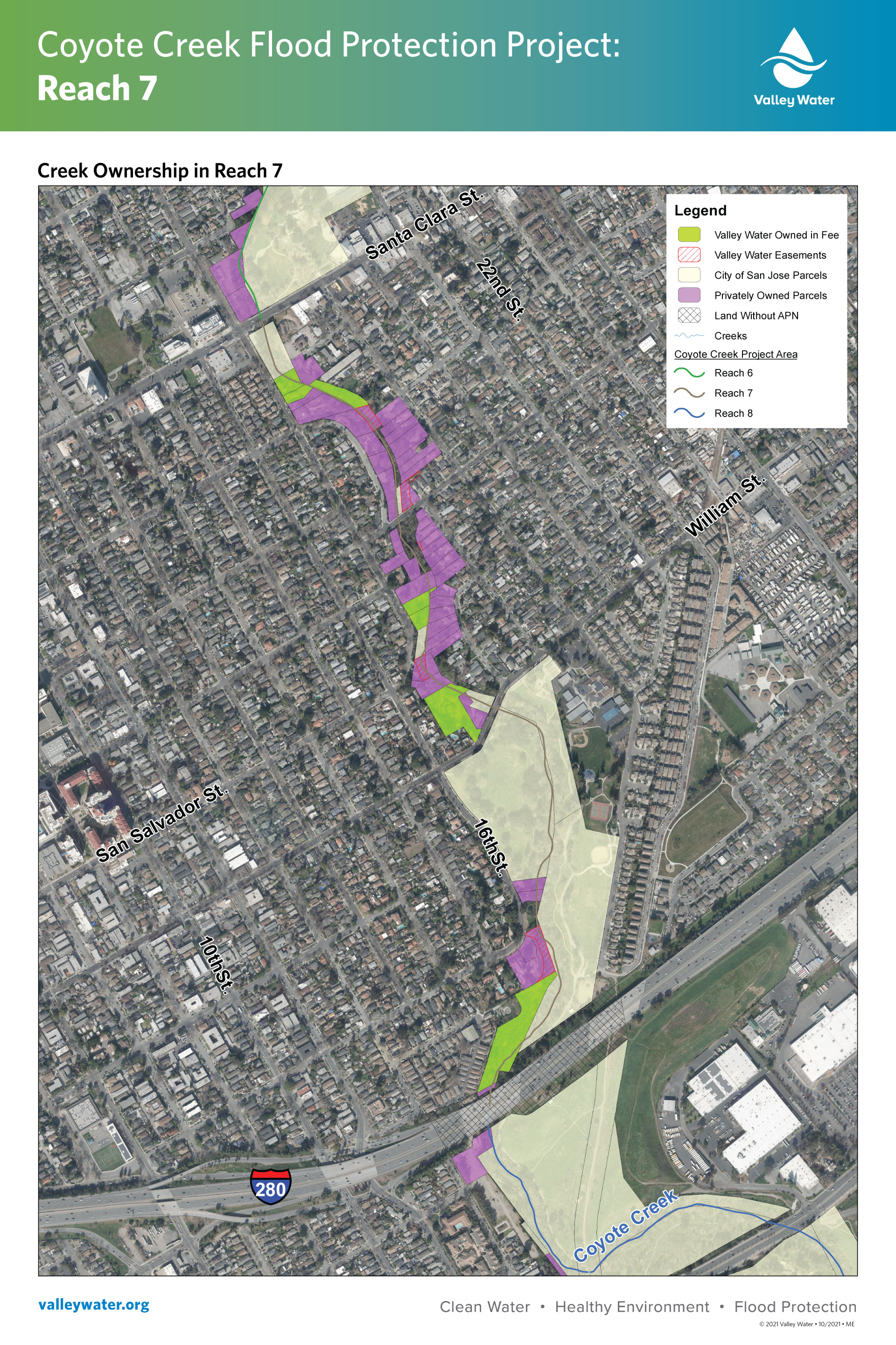
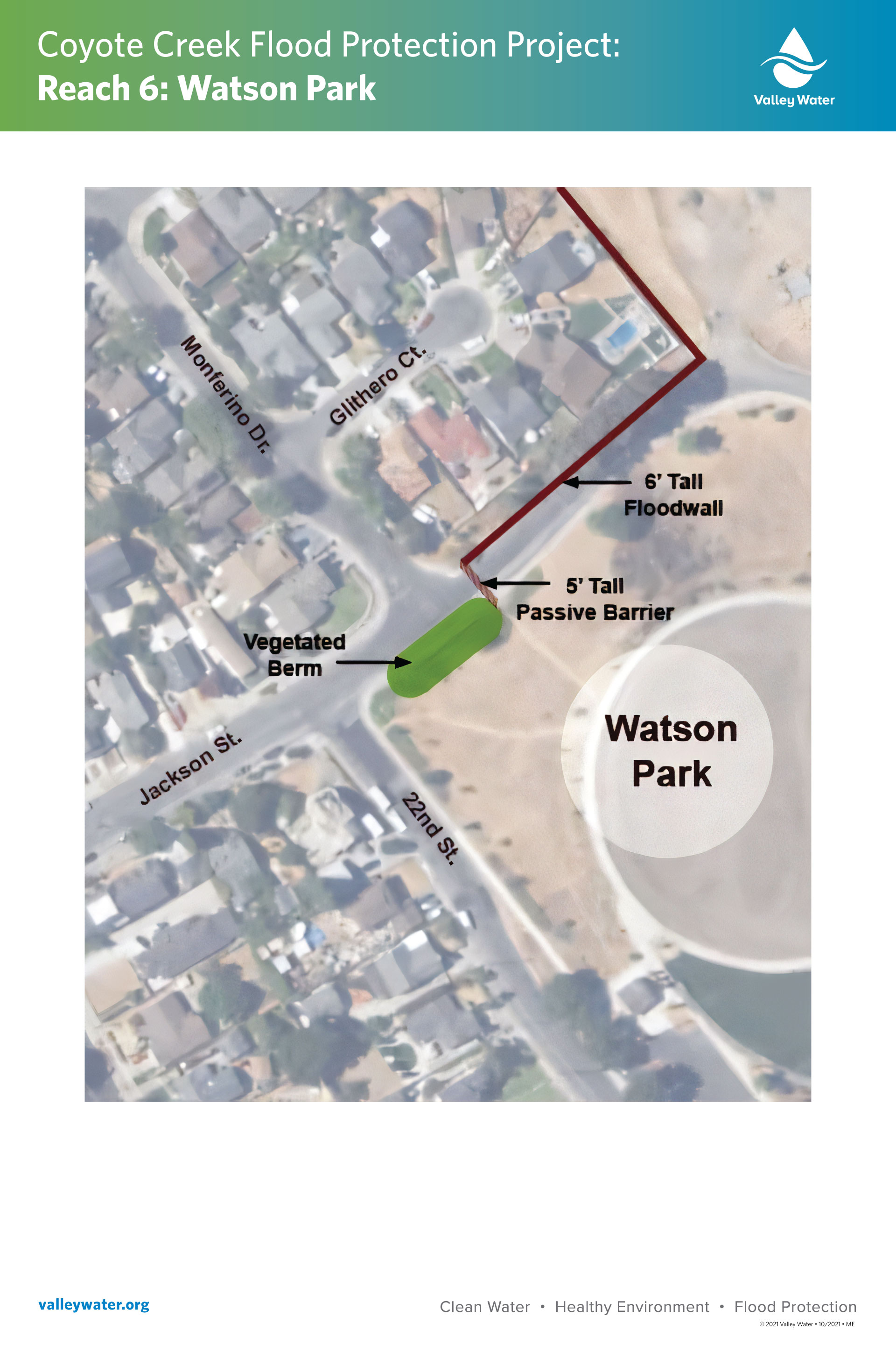
Reach 7: Santa Clara Street to South end of William Street Park and creek ownership map
In fiscal year 2024, quarter 3, crews began installing floodwalls along the west bank of Coyote Creek north of East San Antonio Street and south of Santa Clara Street. The floodwall construction will continue into fiscal year 2024, quarter 4.
Additionally, the contractor carried out clearing and preparation work for floodwall installation at the Coyote Creek Outdoor Classroom Area along the west bank of Coyote Creek north of East William Street, and along the west bank of Coyote Creek just south of William Street Park. Installation of floodwalls at these two locations are anticipated to commence in fiscal year 2024, quarter 4.
Floodwall installation work in the above-mentioned creek areas is anticipated to continue through September 2024. During the project work, you can expect some noise, dust, truck traffic, detours, and minor vibrations typical of construction efforts. Additionally, large construction vehicles will travel on East William Street, East San Salvador Street, East San Carlos Street, East Santa Clara Street, Arroyo Way, South 16th Street, and South 17th Street. Please use caution when near the project area and follow all traffic control measures. Flaggers will be present to safely guide vehicles and pedestrians.
Progress on Coyote Creek Video
Valley Water has built over 5,300 feet of floodwalls along Coyote Creek in San José from June 2023 through March 2024, with another 3,200 feet expected to be completed this year. Click here to see our progress in action.
Past public meetings
Materials from past public meetings are located in the Reports & Documents section.
Visit our Valley Water blog to learn about our community input efforts on the Coyote Creek project.
April 2024
For more information:
- CCFMMP or Phase 1 – Robert Yamane, (408) 630-2925
- CCFPP or Phase 2 – Mohammad Hussaini, (408) 630-2826
- Project Outreach: Jose Villarreal, (408) 630-2879
- Sign up to receive project updates via email.


Click or tap to enlarge the map.


Pre-Construction Activities January 2023
The following notices were shared to inform neighbors of pre-construction activities in preparation for the construction of the CCFMMP:
- Vegetation clearing mailer, and
- Valley Water and the City of San José coordinating to safely relocate the unhoused along sections of Coyote Creek (see inside maps for locations) and a Frequently Asked Questions document.
Previous Public Meeting Materials
Dec. 6 Coyote Creek Flood Protection Project Notice of Preparation and Scoping Meeting
A Notice of Preparation (NOP) and Scoping Meeting on the Environmental Impact Report (EIR) for the Coyote Creek Flood Protection Project was held on December 6, 2023. Meeting participants learned about the project and asked questions about the scope and content of the information. Valley Water has received public comments, which will be addressed in the future Draft EIR. The Notice of Preparation of a Draft Environmental Impact Report is available for download. The comment period is now closed. Materials from the Dec. 6 meeting are available to download.
- Agenda
- Presentation
- Coyote Creek Flood Protection Project maps of reaches (work areas) 4, 6, 7, and 8
- Proposed Flood Risk Reduction Measures and Locations
- Coyote Creek Flood Protection Project information
- Recording of meeting
June 2023 Pre-construction Meetings
Valley Water hosted two pre-construction public meetings for the Coyote Creek Flood Management Measures Project (CCFMMP). Information shared included the planned work, potential impacts on the surrounding areas, and the anticipated project schedule.
Golden Wheel Mobile Home Park
- Agenda
- Presentation
- Survey
- Meeting recording
Roosevelt Community Center
- Agenda
- Presentation
- Survey
- Meeting recording
Board of Directors project update
Valley Water's Board of Directors approved the construction contract for the phase 1 project. The May 16, 2023, agenda (item 6.1) contains the staff memo and other project materials. A recording of the board meeting is available to view. The plans and specifications for the project are part of the February 28, 2023, board meeting. Links to the plans and specifications are located under item 3.3 of the agenda, and the meeting recording is also available for viewing.
May 2022 Open House Events
Valley water hosted two in-person open house events to share details on the Coyote Creek Flood Management Measures Project (CCFMMP). This project includes reaches 5 and parts of 6 and 7. The same project information was shared at both open-house events. Here are the links to the boards that were on display:
- Coyote Creek Flood Protection Project and Coyote Creek Flood Management Measures Project timeline
- Coyote Creek accomplishments (English, Spanish, and Vietnamese)
- Project information, map, and timeline (English, Spanish, and Vietnamese)
You can also view a recording of the open house from our YouTube page.
Public meetings for the remaining reaches of the Coyote Creek Flood Protection Project, 4, 8, and parts of 6 and 7, will be held in late 2023.
February 2022 Public Meeting
Valley Water hosted a virtual public meeting to update neighbors on the Coyote Creek Flood Protection Project and the Coyote Creek Flood Measures Project. Information on the projects’ aesthetics and related design details was shared with attendees who responded to poll questions as options were presented. Information about anticipated project timelines and future public engagement opportunities in the spring and summer was also shared. Here is a link to the recorded meeting.
The results from the aesthetic elements survey are available. The final tally includes results from the meeting and post-survey. The final results are consistent with the input received during the meeting. You can view the presentation for details on the options and visuals shared for each section of the project.
The presentation is available to download.
October 2021 Public Park Meetings
Valley Water, in partnership with the City of San Jose’s Parks, Recreation and Neighborhood Services Department, hosted three public meetings to receive neighborhood input on the proposed flood protection elements located in the City’s parks. Valley Water presented renderings of the various flood reduction elements and a mockup of the preferred alternatives at each park. The collected input will help Valley Water refine further the selected flood reduction alternatives as the projects proceed to the 30% design phase.
October 7 Rocksprings Park and Coyote Meadows
Meeting Materials
- Video recording of the meeting
- Agenda
- Informational sheet
- Survey and comment card
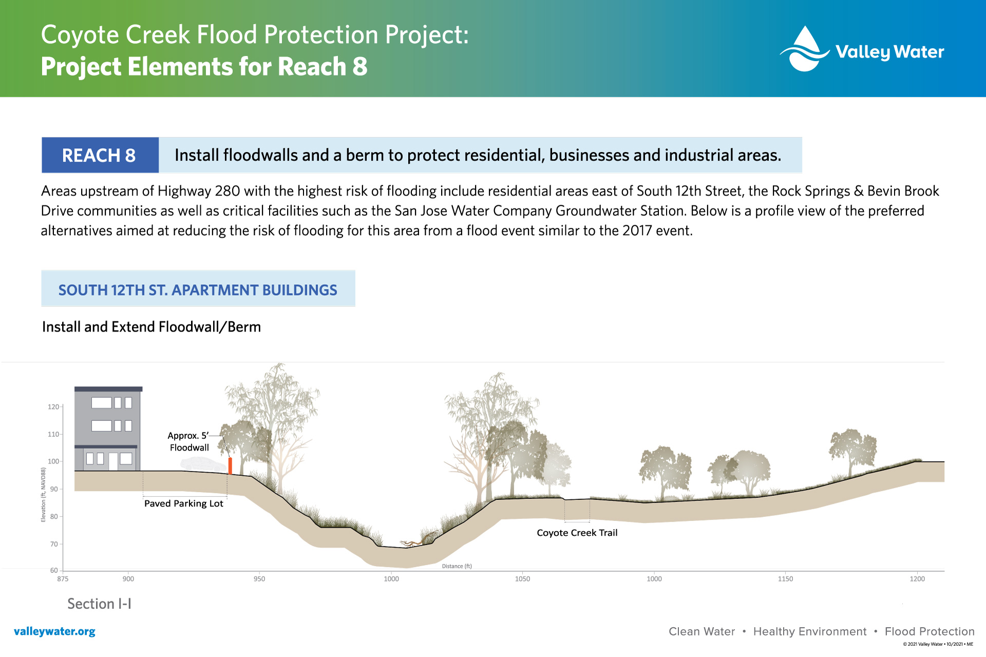
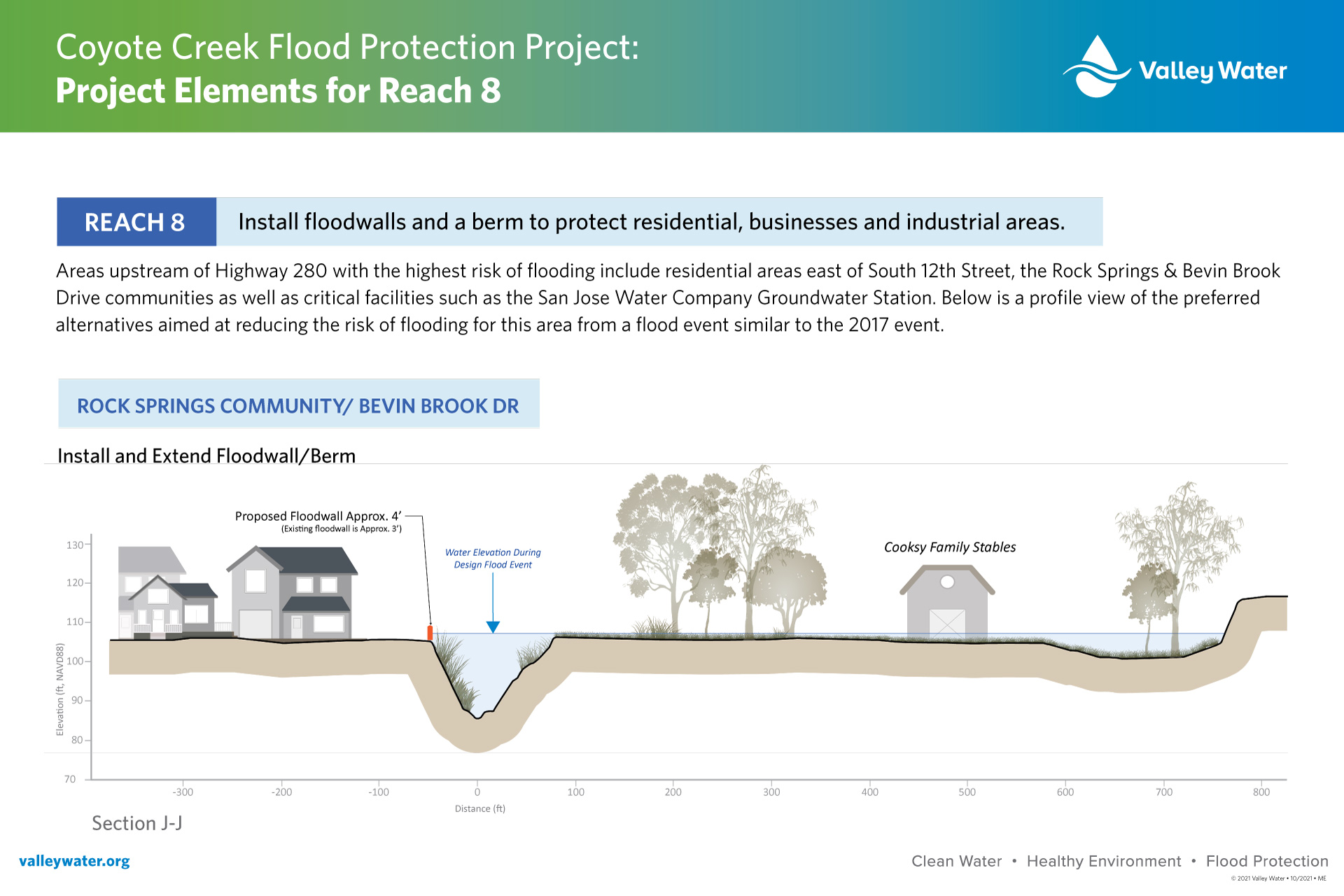
Display Board for Reach 8
- South 12 Street Apartment Buildings
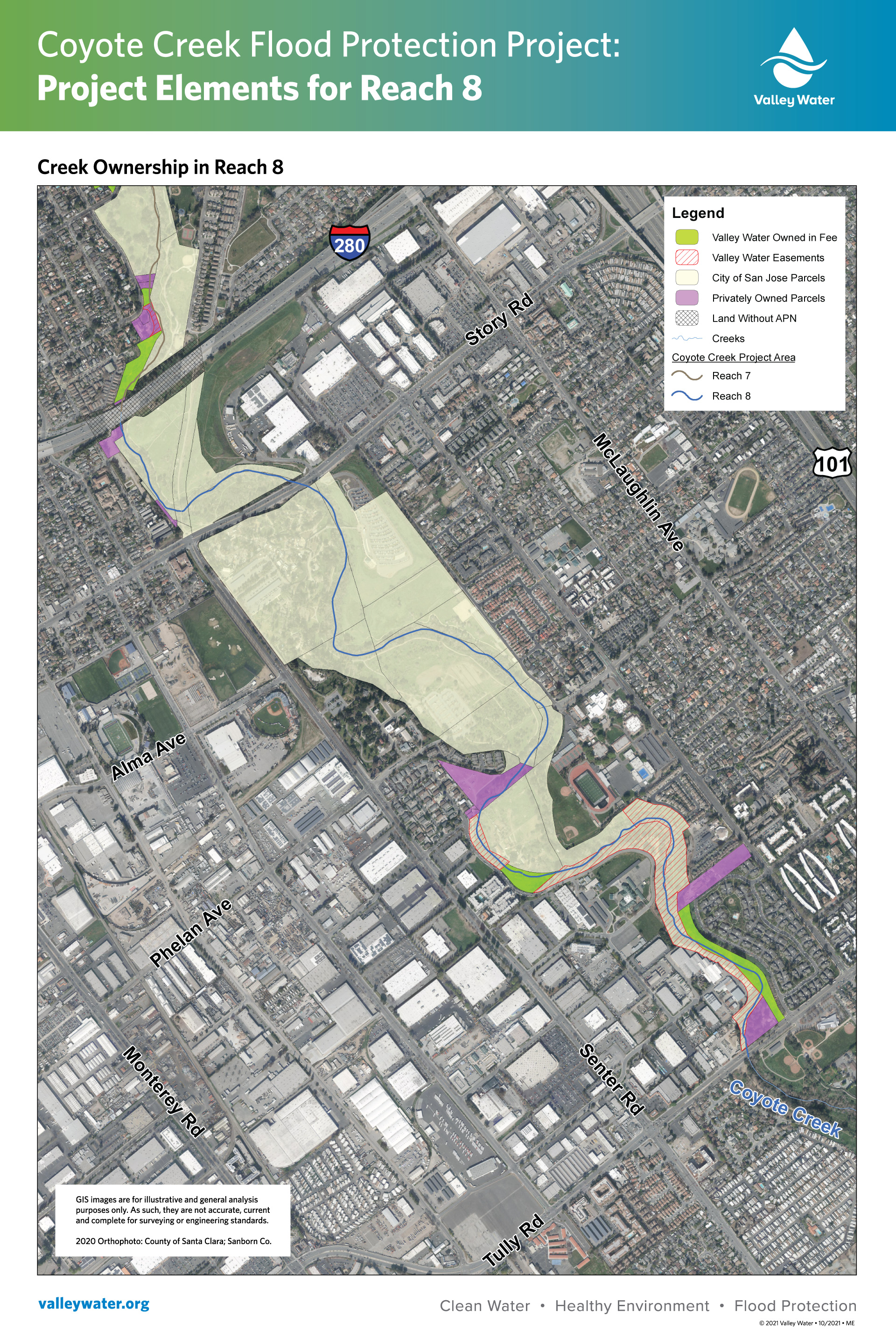
- Map of Property Parcels
- Project Overview Map
- Installing Floodwalls and Berm to protect residential, business, and industrial areas
- Rocksprings Community and Bevin Brook
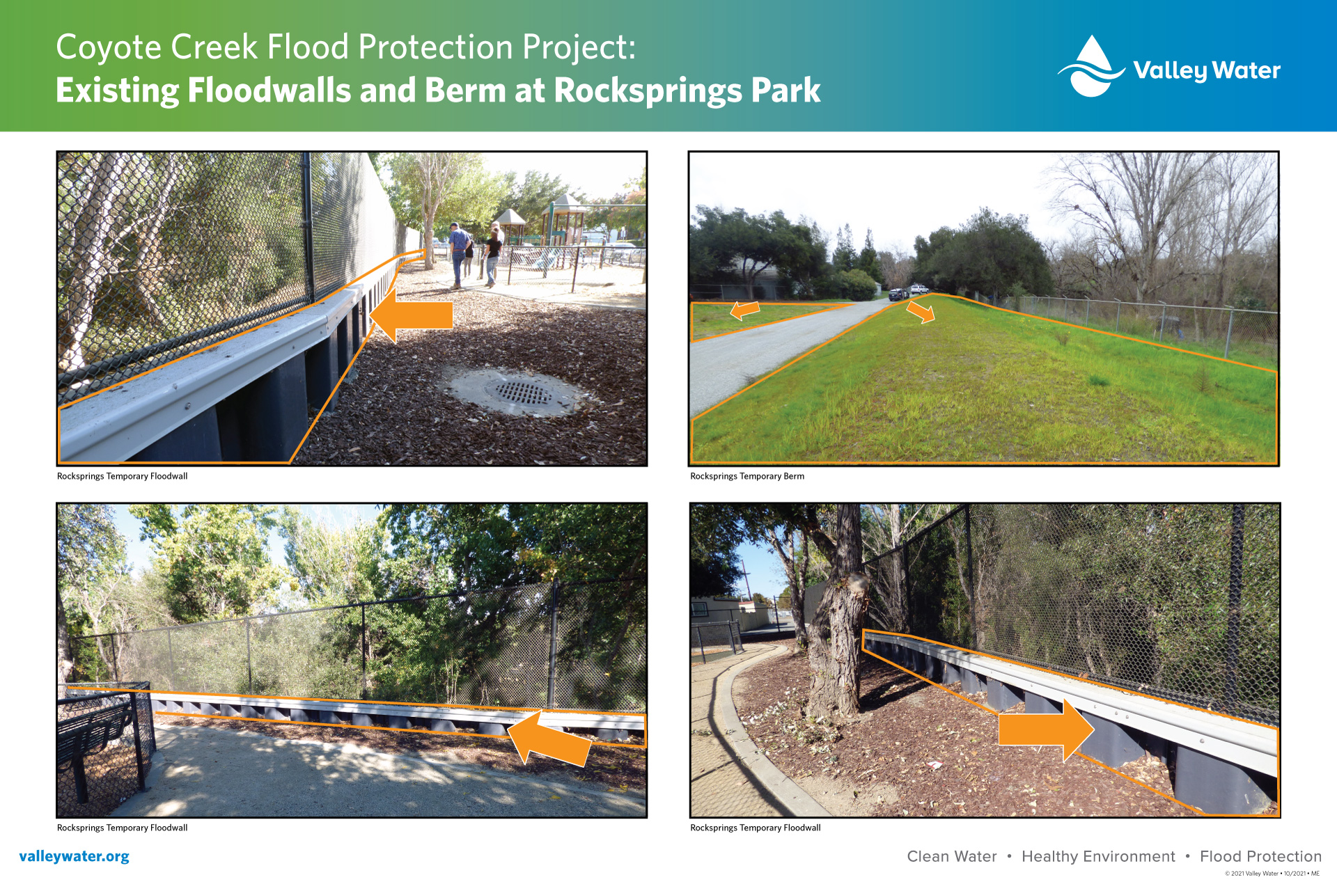
- Existing Floodwalls and Berm
October 13 Selma Olinder Park and William Street Park
Meeting Materials
- Video recording of the meeting
- Agenda
- Informational project sheet
- Survey and comment card
- Frequently Asked Questions
Display Boards for Reach 7
- Project Overview Map
- Reach 7 Ownership Map
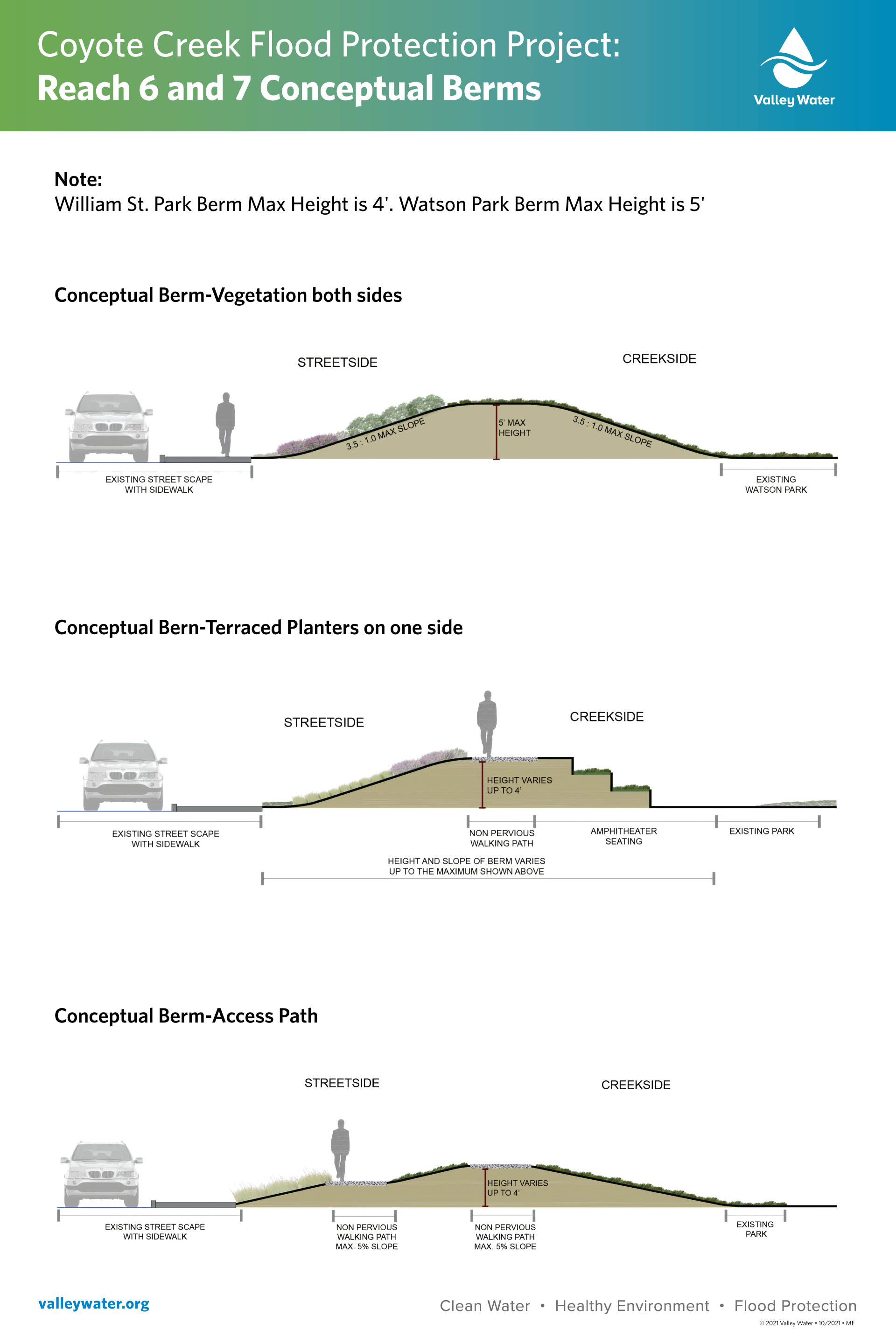
- Conceptual Berms
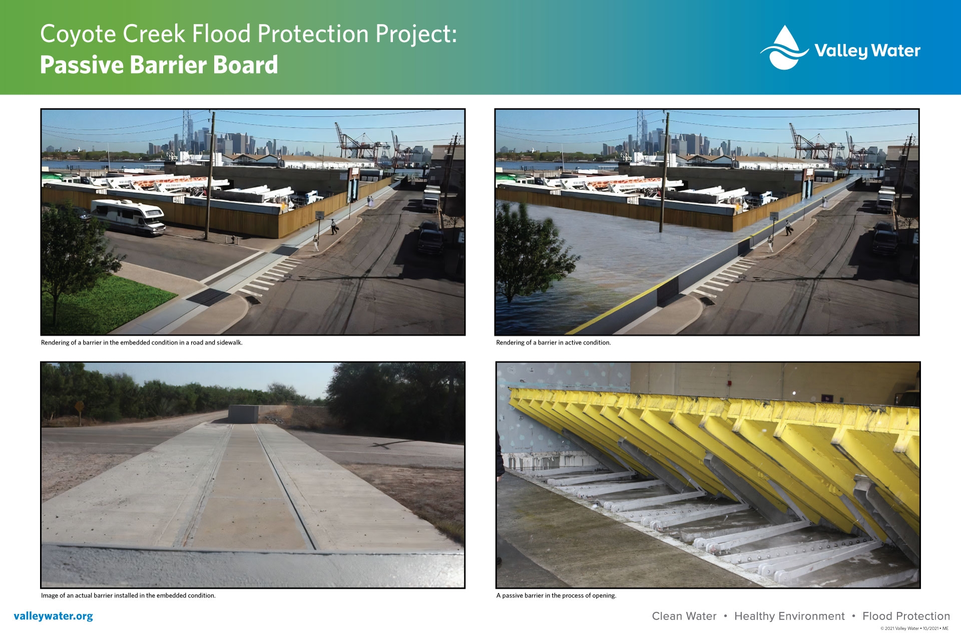
- Passive Barrier
- William Street Park
October 14 Watson Park
Meeting Materials
- Video recording of the meeting
- Agenda
- Informational project sheet
- Survey and comment card
Display Boards for Reach 6
- Reach 6 Coyote Creek Ownership Map
- Reach 6 Watson Park
- Project Overview Map
Display Boards for Reaches 4 and 5
- Reach 4 Ownership Map
- Reach 5 Ownership Map
July 2021
Valley Water hosted a meeting to update neighbors on the Coyote Creek Flood Protection Project and the Federal Energy Regulatory Commission Order Compliance Project, known as the Coyote Creek Flood Management Measures Project. Valley Water provided an update on the project’s progress, current efforts, and next steps as we prepare for fall public meetings (meeting notice).
Meeting materials
- Watch the meeting video
- Agenda
- Presentation
- Frequently Asked Questions (FAQ)
June 2020
Virtual public meetings were held in June 2020 to present the preferred project alternatives to the public and stakeholders.
June 10 focused on the communities of Golden Wheel, Riverbend, and South Bay mobile home parks.
- Watch the meeting video
- Agenda
- Presentations:
- Reaches 4 to 5 preferred alternatives poster board
- Anderson Dam Seismic Retrofit Project materials
June 11 focused on the communities of Bevin Brook, Nordale, and Rock Springs.
- Watch meeting video
- Agenda
- Presentations
- Reach 8 preferred alternatives poster board
- Anderson Dam Seismic Retrofit Project materials
June 17 focused on the communities of Bonita-24th Street, Brookwood Terrace, Five Wounds, Julian-St. James, Naglee Park, Olinder, Roosevelt, and Wooster.
- Watch meeting video
- Agenda
- Presentations
- Reaches 6 & 7 preferred alternatives poster board
- Anderson Dam Seismic Retrofit Project materials
The following presentation was provided to the San Jose Parks Advocates. The presentation is solely focused on the proposed alternatives for Watson, William Street, Selma Olinder, Coyote Meadows, and Rocksprings parks.
January 2020
- SJ Parks Advocates presentation
November 2019
In November another series of public meetings were held to get community input during the planning phase of the project.
November 13 at the Roosevelt Community Center:
November 7at the Franklin McKinley School District:
November 6 at the Golden Wheel Mobile Home Park (Club House):
June 2019
The following is a series of meetings held to update the community and solicit input on the planning phase of the project.
June 3 at the Roosevelt Community Center:
- Agenda
- Presentation
- Reaches 6 and 7 Spilling Map
- Reaches 6 and 7 Conceptuals
- Facebook Live meeting video
May 30 at the Franklin-McKinley School District:
- Agenda
- Presentation
- Reach 5 Railroad - Cross Sections Poster
- Reach 8 Spilling Map
- Reach 8 Conceptual
- 1. History and Location
- 2. Reaches and Cross Sections
- 3. Conceptual William Street Park
- 4. Conceptual Arroyo Way #1
- 5. Conceptual Flea Market
- 6. Conceptual Arroyo Way #2
- Facebook Live meeting video
May 21 at the San Jose Conservation Corps:
- Agenda
- Presentation
- Reaches 4 and 5 Breakout Locations: Montague Expw to Mabury Rd.
- Reached 4 and 5 Conceptual: Montague Expw to Mabury Rd
- Resolution announcement and frequently asked questions
- Facebook Live meeting video
Frequently Asked Questions
Public meetings were held in May, June, and November of 2019. Questions from those meetings were combined and summarized to develop the content of this comprehensive 2020 FAQ document. Please note that many of the questions were addressed during those public presentations and video recordings of them are available to view in the above presentations.
Relocation Plan
Here is a link to the Relocation Plan, which only affects the thirteen identified properties that received a mailed notice. Although a final decision has not been made for any of the 13 properties, federal and state laws require Valley Water to develop a Relocation Plan. California law also requires that a Relocation Plan be adopted by the lead agency’s governing board, even when final property decisions have not been made.
Planning Study Report (PSR)
The PSR for the Coyote Creek Flood Protection Project and Coyote Creek Flood Management Measures Project documents the planning phase project formulation for reducing the current risk of flooding along Coyote Creek from Montague Expressway to Tully Road in San Jose.
Coyote Creek Study Reports
Fisheries
Vegetation and wildlife assessment:
A Valley Water sponsored study of the Coyote Creek historical ecology done by the San Francisco Bay Estuary Institute in 2006.
-
Executive Summary - Coyote Creek watershed Historical Ecology study
-
Final Report - Coyote Creek Watershed Historical Ecology Study - part 1
-
Final Report - Coyote Creek Watershed Historical Ecology Study - part 2
-
Final Report - Coyote Creek Watershed Historical Ecology Study - part 3
-
Final Report - Coyote Creek Watershed Historical Ecology Study - part 4
FY22-36 Key Performance Indicator for the Safe, Clean Water Program
- Construct flood protection improvements along Coyote Creek between Montague Expressway and Tully Road to provide protection from floods up to the level that occurred on February 21, 2017, approximately a 5% (20-year) flood event.
Benefits
-
Protects approximately 600 parcels from the level of flooding that occurred on February 21, 2017, approximately a 5% flood
-
Improves water quality, enhances stream habitat and increases recreational opportunities
-
Provides opportunities to incorporate revegetation and aesthetic elements to the Coyote Creek park chain in the project
-
Addresses climate change
Geographic Area of Benefit
San José - The project area is approximately 9 miles from Montague Expressway upstream to Tully Road.

Flooding History
Flooding has occurred many times within the Coyote Creek Watershed, including along portions of Coyote Creek in 1911, 1917, 1931, 1958, 1969, 1982, 1983, 1997, 1998, and 2017. The largest flow recorded on Coyote Creek was 25,000 cubic feet per second in 1911, before the construction of the current two water-supply reservoirs in the upper watershed. The worst flooding in the project reach since Anderson Reservoir was constructed in 1950 occurred in February 2017. Coyote Creek overtopped its banks at several locations between Montague Expressway and Tully Road. Businesses and hundreds of homes were inundated by creek waters for many hours. Highway 101 near Watson Park and various local streets were closed due to flooding, and thousands of residents had to be evacuated and sheltered.
Project Background
The Coyote Creek Flood Protection Project was initially part of the voter-approved Clean, Safe Creeks and Natural Flood Protection Plan (CSC Plan) that came into effect in Fiscal Year 2001-2002 (FY02). The project entailed planning, designing, and partially constructing flood protection measures along an approximately six-mile stretch of Coyote Creek, extending upstream of Montague Expressway to Interstate 280. The project objective was to protect 1,400 parcels from 1% flood eventually.
Under the CSC Plan, Valley Water performed geomorphic and floodplain analysis, prepared a problem definition report, held multiple community meetings to receive input, completed conceptual alternatives analysis, and prepared the Planning Study Report (PSR). A range of conceptual alternatives was developed to address the Coyote Creek Project objectives and the cost of all the alternatives significantly exceeded the project budget. In 2011, the 100-year (1%) flood risk reduction improvements cost was estimated between $500 million and $1 billion. With no federal funding, Valley Water proceeded to design only the downstream reaches of the Coyote Creek Project (Montague Expressway to Highway 880).
Voters Approve the 2012 Safe, Clean Water Program
In November 2012, voters approved the Safe, Clean Water and Natural Flood Protection Program (2012 Program), which replaced the CSC Plan. The project was continued in the 2012 Program with the key performance indicator (KPI) to “Complete construction of downstream project elements.”
The project was delayed due to various developments, including extremely high project cost estimates and the absence of federal funding, which was critical to Valley Water’s ability to construct the project. Furthermore, potentially feasible project alternatives for a 1% level of protection depended significantly on the outcome of various ongoing projects, including the Anderson Dam Seismic Retrofit Project, which could impact the flows into Coyote Creek. As a result, in FY16, the project was placed on hold until FY19.
After significant flooding in 2017, the project was modified to extend the project reach by approximately 2.9 miles upstream to Tully Road to include the Rock Springs neighborhood and incorporate the areas impacted by the flood event. In addition, the target protection level was revised to match the February 2017 flood (approximately a 20-to 25-year event), which was the largest flow seen in Coyote Creek since 1950. This allowed Valley Water to address the flood threat to the community without depending on the progress of other projects and their impacts on Coyote Creek flows. Furthermore, Valley Water implemented short-term relief solutions to reduce flood risk. Details about the 2017 modification can be found at https://scvwd.legistar.com/LegislationDetail.aspx?ID=3064265&GUID=D843FFA6-6EA4-4825-9A8F-76221C76BB82.
Following a February 2020 direction from the Federal Energy Regulatory Commission (FERC) regarding the Anderson Dam Seismic Retrofit Project, the Coyote Creek Project was split into two projects: the Coyote Creek Flood Management Measures Project (CCFMMP) and the Coyote Creek Flood Protection Project (CCFPP). The CCFMMP focuses on building flood management measures to handle potential releases from the larger outlet tunnel at Anderson Dam.
Voters Approve the Renewed Safe, Clean Water Program
In November 2020, voters approved the renewed Safe, Clean Water and Natural Flood Protection Program (Safe, Clean Water Program), replacing the 2012 Program. The project has continued in the renewed Safe, Clean Water Program.
About the Safe, Clean Water and Natural Flood Protection Program
In November 2020, voters in Santa Clara County overwhelmingly approved Measure S, a renewal of Valley Water’s Safe, Clean Water and Natural Flood Protection Program.
The program was first passed by voters in 2000 as the Clean, Safe Creeks and Natural Flood Protection Plan, then again in 2012 as the Safe, Clean Water and Natural Flood Protection Program. The renewal of the Safe, Clean Water Program will continue to provide approximately $47 million annually for local projects that deliver safe, clean water, natural flood protection, and environmental stewardship to all the communities we serve in Santa Clara County.
While evaluating ways to improve the 2012 program, Valley Water gathered feedback from more than 21,000 community members. That helped Valley Water create the six priorities for the renewed Safe, Clean Water Program, which are:
Priority A: Ensure a Safe, Reliable Water Supply
Priority B: Reduce Toxins, Hazards and Contaminants in our Waterways
Priority C: Protect our Water Supply and Dams from Earthquakes and Other Natural Disasters
Priority D: Restore Wildlife Habitat and Provide Open Space
Priority E: Provide Flood Protection to Homes, Businesses, Schools, Streets and Highways
Priority F: Support Public Health and Public Safety for Our Community
Each year, Valley Water prepares a report providing a progress update for each of these program priorities, along with fiscal year accomplishments.
To ensure transparency and accountability to the voters, the ballot measure also created an Independent Monitoring Committee, appointed by the Santa Clara Valley Water District Board of Directors. The Independent Monitoring Committee annually reviews the program’s progress to ensure the outcomes are achieved in a cost-efficient manner and reports its findings to the Board. Additionally, the IMC also reviews each proposed 5-year implementation plan prior to its submittal for Board approval.
In addition, the program requires three independent audits.